
Road Facts
County Highways
Reference Routes
Little Green Signs
Special Features
Interchange of the Week
What's New?
Links
Contact ESR
Visitors since 02/09/01

View Guestbook
Sign Guestbook
LITTLE GREEN SIGNS
Interchange ramps
Marker placement: Markers are placed at the beginning and end of the ramp; intermediate markers are placed at approximate tenth-mile intervals starting from the first marker. If the last intermediate marker is less than 0.05 miles from the ending marker, it is not placed. If the beginning of the ramp is less than 0.05 miles from the previous marker on the mainline, then the first ramp marker is placed approximately 0.1 miles from this mainline marker. If the ramp begins more than 0.05 miles from the previous mainline marker, then the first ramp marker is placed at the start of the ramp.
[In Region 11 (New York City), a further guideline applies. If a ramp is less than 0.25 miles in length, a single marker is placed at its midpoint. If it is longer, the above technique is used.]
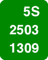
Marker legend: The route number in the top line is that of the route at which the ramp begins; that is, the route from which traffic has just departed. If this route is not a numbered route, the route number given is that of the route at which the ramp ends. If the ramp intersects a service road, the route number is that of the mainline route associated with the service road.
In an older system, the "to" route number was not used. Rather, special codes existed for "from" roads that were not numbered routes. The codes were S00, C00, T00, V00 and M00 (all with zeroes). These appear to mean State, County, Town, Village and Municipal (city), depending on the entity having jurisdicion of the road. This system is no longer being applied but examples are still common. In the case of ramps beginning at numbered county routes, recently installed markers have adopted a "C" affix (placed inconsistently before or after the number).
In place of the county order number, an interchange order number appears. These increase from 01 at the first interchange in each county in the direction of inventory. Where two numbered routes overlap, the interchange number is taken from the higher-level route. Interstates are higher than US routes, which are higher than NY routes. When the overlapping routes are of the same level, the lower-numbered route determines the interchange number used.
If a new interchange is constructed, rather than renumbering all interchanges in the county, the next higher available number in that county is used. This system allows for 99 interchanges in each county. In the unlikely event that any county should ever have more than 99, then number-letter combinations will be used, from 1A, 1B, etc. to 9Y and 9Z. The letter O is omitted from this series.
In the case of ramps at service road interchanges, the interchange number is in the format of A1 through Z9, omitting O1 through O9 and R1 through R9 (the latter are used for rest areas).
[In Region 11 (New York City), instead of an interchange number, the code MR or CR is given. M represents mainlines, C represents collector/distributor roads, and R stands for ramp. The interchange number in Region 11 is moved to the first two digits of the bottom line.]
The first digit of the bottom line indicates the DOT Residency, which is a further division of a Region.
The second space in the bottom line is filled by a letter from A to M. This identifies the individual ramp within the interchange. The letter A is assigned to the ramp on the higher-level route that is oriented either west/east or south/north; letters are assigned consecutively in a counterclockwise direction. This guideline seems to leave much room for interpretation in the more complicated interchanges.
[These two digits, in Region 11, are used instead for the interchange number.]
The last two digits of the bottom line are the sequence numbers. These are the same as those on mainline routes, but require only two digits since no ramp is longer than 9.99 miles (the hundredths figure being dropped).
[In Region 11, these last two digits are the ramp letter and a single sequencing number.]