Interchange of the Week
Monday, 2 July 2001
Monday, 2 July 2001
I-790, NY 5, NY 5A, NY 5S, NY 8 & NY 12, Utica
 |
| A full-size image (536 kb) is also available. |
|
|
| A full-size image (536 kb) is also available. |
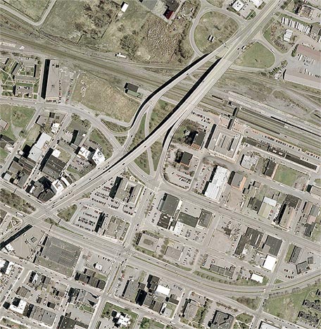
Orientation: Utica's North-South Arterial runs from bottom to top, carrying throughout this length the overlapping NY routes 5, 8 and 12. It also carries Interstate 790, which has its terminus at the Oriskany Boulevard overpass, bottom center. At this overpass is also the terminus of both NY 5A and NY 5S, the former running along Oriskany Boulevard to the left and the latter to the right. At bottom right, Oriskany Boulevard becomes Liberty Street.
State Street enters at bottom, one block east of the North-South Arterial. It crosses Lafayette Street and ends at the ramp from NY 5A.
The CSX Transportation mainline runs from left to right through the north part of the interchange.
Exit numbers: Exits are not numbered on I-790.
The interchange: This is a rather unusual form of "folded" diamond (where two of the ramps are relocated across the intersecting road as loop ramps) or half-cloverleaf. Much of its complexity stems from the fact that Oriskany Boulevard (NY 5A) offers an exit for State Street just before reaching the North-South Arterial overpass, while the through lanes of Oriskany Boulevard (becoming NY 5S) bypass this junction. Therefore, the southbound exit ramp from the Arterial offers three different connections: 1) to NY 5A westbound, 2) to NY 5S eastbound, and 3) to State Street. Similarly, the Arterial's northbound exit ramp connects to NY 5A westbound, and also to State Street by means of an overpass over Oriskany Boulevard (meeting the latter's State Street ramp at the crossroads with State Street itself). The northbound entrance ramp to the Arterial is likewise split. Notice that there are no dedicated connections between NY 5A and the northbound Arterial. Therefore, the NY 5A exit to State Street must serve this double duty.
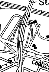
An earlier version of this interchange (shown at right) involves an even more unusual type of "folded" diamond, featuring a three-level crossover just south of the railroad. Notice also the number of minor streets that were removed with the rebuilding of the interchange. The NY 5A-NY 5S corridor throughout the City of Utica displays a considerable amount of urban renewal-style land clearing and street realignment.
 |
Orientation: NY 5S enters at left on Liberty Street, then continues towards the right along the East-West Arterial. Genesee Street runs from lower left to top right; it carries the reference route 921C designation north of NY 5S. Broad Street enters at right, just north of NY 5S. West of the interchange with Genesee Street it becomes Whitesboro Street. John Street runs south from Broad Street just east of Genesee Street; from Broad Street to NY 5S it carries reference route 921P.
The interchange: Another of Utica's fascinating assortment of interchanges, this one involves only local streets (not unlike NY 5, NY 30 and NY 67 at Amsterdam), having only indirect connections to NY 5S. The substantially upgraded Genesee Street passes over Broad Street and the CSX railroad yard on a viaduct, and connects to Broad and John Streets by means of several ramps. Northbound, the connection is made by means of NY 5S, although there is also a connection to Catherine Street one block to the north. The northbound entrance is a ramp from the intersection of Broad and John Streets. Southbound, the connections are more interesting. The exit ramp splits into left and right branches, both of which cross Broad Street. However, only the right-hand branch is used for the Broad Street connection (as well as re-entry to Genesee Stret southbound). The left branch is used for access to John Street and NY 5S only.
Other features: NY 5S intersects with the various local streets in a fairly controlled manner, by means of channelized turns and elimination of cross traffic from minor streets. Jay Street acts as a frontage road for the first few blocks of the NY 5S Arterial, and the latter has a slip ramp to Jay Street just before curving away to the northeast. Various other restricted turn movements can be identified upon close inspection of the photo. Also, Genesee Street has a grade-separated connection to Lee Street and industrial areas along the north side of the railroad, provided by a set of small ramps that also serve as a U-turn for Genesee Street itself.
 For this week's Stub of the
Week, see Week 17 for a discussion of the
Utica Rome Expressway (NY 49) extension westward from I-790.
For this week's Stub of the
Week, see Week 17 for a discussion of the
Utica Rome Expressway (NY 49) extension westward from I-790. 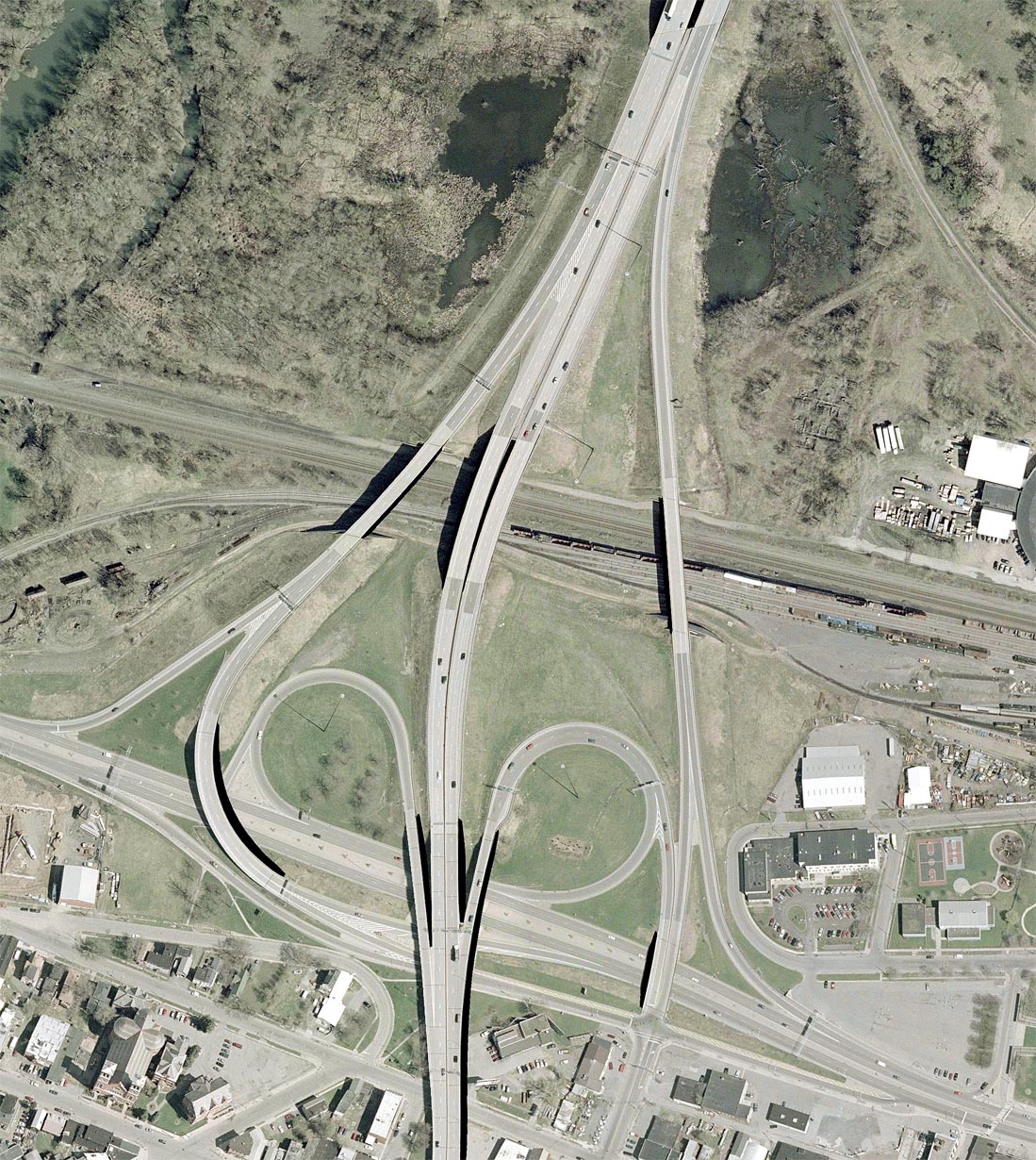