Interchange of the Week
Monday, 27 November 2000
Monday, 27 November 2000
NY 5, NY 30 & NY 67, Amsterdam
 |
|
|
|
|
|
|
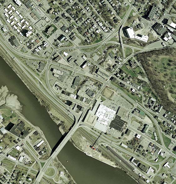
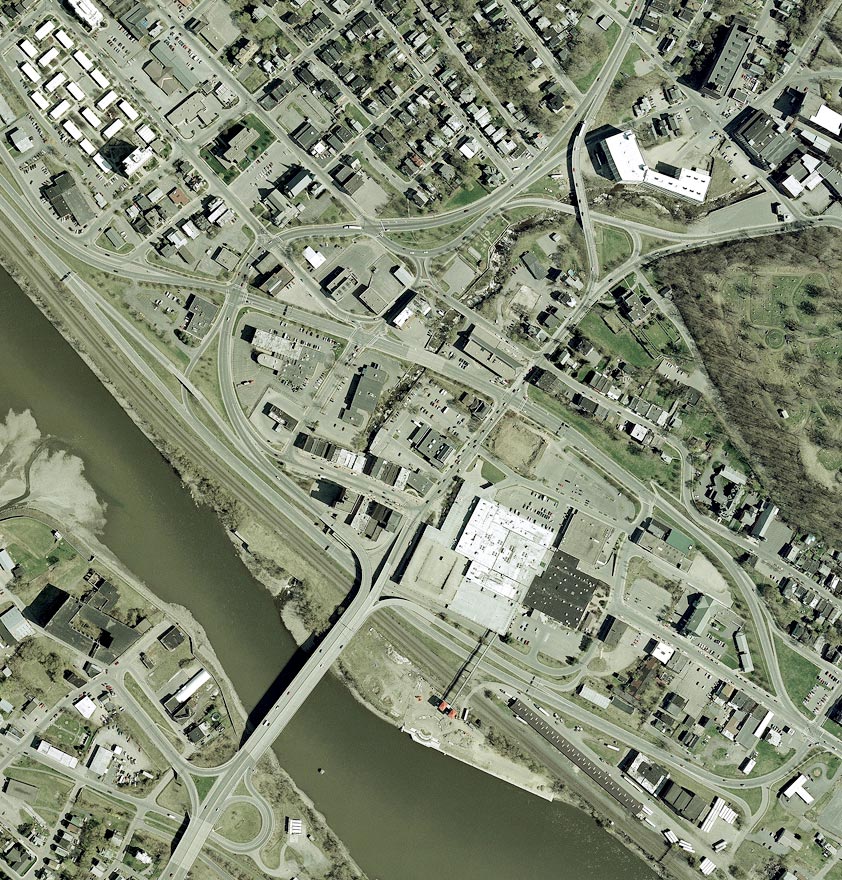
Orientation: The City of Amsterdam lies on either side of the Mohawk River, which is also the route of the Erie Canal. NY 5 runs along the river's north shore, splitting into two separate one-way roadways through downtown Amsterdam, shown here. NY 30 is the north-south route crossing the Mohawk on the New Amsterdam Bridge. It also splits into opposing roadways through the business district, and exits the photo at top. NY 67 enters at left, overlapping NY 5, and then turns north on the two roadways of NY 30. Finally, it branches off to the east (top right). The CSX Transportation mainline runs between NY 5 and the Mohawk River.
The interchange: This interesting arrangement is not properly a single interchange, but rather the result of two urban planning techniques typical of the tight Mohawk Valley communities. The first of these is to increase traffic capacity on through routes without widening existing streets, thereby preserving buildings of historic and architectural interest. Instead, opposing directions of traffic are routed onto different existing streets, which are made into one-way, multi-lane thoroughfares. This is exemplified here by the routing of NY 30 northbound.
The second technique is the result of typical 1970's urban-renewal design principles, in which new highway alignments are created, cutting across older street grid patterns and involving the clearance of large sections of blighted neighborhoods. NY 30 southbound and both directions of NY 5 are examples of this. NY 5 eastbound, in particular, was designed to open the waterfront for better public access. Another aspect of this technique is that older streets are truncated or dissected, entire blocks often being removed. Here, Main Street, which originally carried NY 5, runs between and parallel to the new roadways, and is interrupted by the site of the Amsterdam Mall.
Individual routings:
NY 5: NY 5 comes from the west on a riverside alignment, one block south of Main Street. Whereas the westbound lanes curve away to the north, the eastbound roadway continues along the river, where a left-hand ramp rises up to meet NY 30 southbound (after crossing over a ramp from the same). On NY 5, just before the New Amsterdam Bridge, a connector leads left to Main Street, on which westbound traffic is permitted for two blocks to Market Street. Directly beneath the bridge, another connector leads to northbound NY 30. From this, there is a branch to the old alignment of Cherry Street, which turns left after one block as Liberty Street, providing access to the Amsterdam Mall.
In the westbound direction, NY 5 enters on Main Street and splits at Schuyler Street. It blazes a new path, cutting off half a dozen old streets and intersecting at grade the two alignments of NY 30. Just before the NY 5 roadways re-converge, the westernmost segment of Main Street branches to the right. It keeps within one block of NY 5, which follows it again farther west before leaving the city limits.
NY 30: This route comes from the south on an express North-South Arterial, bypassing crowded older streets in the South Amsterdam section of the city. Before crossing the Mohawk River, NY 30 has an interchange with these streets. The interchange resembles a "trumpet" configuration, except that the northbound and southbound ramps connect to different surface streets. The northbound ramps curve around to become Erie Street, which crosses Minaville Street and then Bridge Street (extreme left). The southbound ramps cross over Minaville Street, and come to an end directly at Bridge Street. Apparent in this photo are the prevailing traffic movements to and from the south at this point, but it is also plainly visible where the former Amsterdam Bridge was, as Bridge Street abuts the river one block to the north.
Crossing the river (as well as the railroad and eastbound NY 5) on NY 30 northbound, there is a ramp to NY 5 eastbound that also serves Liberty Street and the mall. NY 30 crosses NY 5 westbound at grade, then has an intersection with NY 67. NY 30 crosses over the southbound lanes of NY 67, as well as Shuler Street, before converging with the southbound alignment. The southbound roadway cuts diagonally across several older streets, crossing Park Avenue, Division Street and NY 5 westbound. A right-hand ramp leads to NY 5 eastbound, a left-hand ramp to Main Street, and through traffic rises up to the bridge level, curving south over NY 5 and the railroad to rejoin NY 30 northbound on the New Amsterdam Bridge.
The divided roadways of NY 30 essentially enclose the business district within a loop. Inside this loop, intersections of local streets are extensively channelized, and one-way stretches abound. Careful study of the photo will disclose much about the arrangement of traffic flow in this area.
NY 67: NY 67 comes in from the east on Church Street and
splits just west of Prospect Street. The westbound lanes cross under NY
30 northbound, then join with Shuler Street before turning left onto NY
30 southbound. Two blocks beyond, NY 67 turns right onto NY 5
westbound, which it overlaps into the village of Fort Johnson, just
west of Amsterdam. In the opposite direction, NY 67 eastbound overlaps
NY 5 eastbound until the ramp directly beneath the bridge. It follows
this to NY 30 northbound, then branches off onto Church Street at top
right.
<< Back