Interchange of the Week
Monday, 5 January 2004
Monday, 5 January 2004
Inner Loop, Rochester: Part 1
 |
|
|
|
|
|
|
Rochester's Inner Loop is a freeway encircling the city's downtown
area. It was proposed in 1947 and constructed between 1952 and 1974.
The last piece completed was the portion west of Plymouth Avenue. As
first built in 1965, the Inner Loop followed Plymouth Avenue to close
the gap. To this day, Plymouth Avenue is retained as a state highway
(reference route 942G). Fascinating as this
highway is, it was
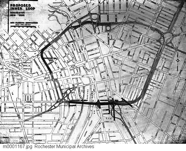
originally proposed to be considerably more intricate, as shown in this image from the City Planning
Commission dated 1951.
Today, the southwestern quarter of the loop carries Interstate 490, which branches off to the west and southeast. The remainder of the Inner Loop is state reference route 940T. It is interesting that the non-Interstate portion of the Inner Loop carries a higher speed limit (45 mph) than the I-490 stretch (40 mph). This may be due to concerns about heavy trucks negotiating the sharp curves through Exits 13 and 15. Even with the low speed limit, overturned tractor-trailers are a fairly common occurence on this part of the Inner Loop.
There are two bridges over the Genesee River on the Inner Loop. I-490 crosses the river on the Troup-Howell Bridge, named for surface streets on each side of the river that were connected by the bridge when it was first built. The bridge will be replaced with a steel arch structure as part of the ongoing "490 Gateway" reconstruction program. On the north side of the loop, the river is spanned by a smaller structure loacted at the brink of the High Falls of the Genesee, alongside the CSX railroad bridge. The present Inner Loop bridge occupies the site of the old Central Avenue Bridge.
Three numbered exits on I-490 fall within the loop. Exit 15, located at the six o'clock position on the loop, is discussed in detail in Week 20. Continuing clockwise from that point, the succeeding interchanges are discussed below.
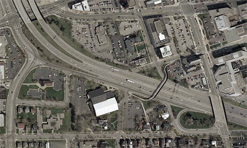
Exit 14 consists, in essence, of a folded half diamond (see Week 59) with South Plymouth Avenue (right), providing access to and from the east only. In this case, Spring Street, one of several streets cut by I-490 through the Corn Hill district, serves as part of the loop ramp, and there is also the option of proceeding straight ahead onto South Washington Street. Signage for Exit 14 indicates Broad Street (via Washington Street) and Plymouth Avenue (via Spring Street). The entrance ramp from South Plymouth Avenue has a reference marker for NY 383: before Plymouth Avenue was rerouted around the Corn Hill neighborhood, it carried the designation now given to Exchange Boulevard.
Boys Club Place acts as a service road along the eastbound side of
I-490; it feeds into the entrance ramp from South Plymouth Avenue. It
is essentially a long entrance ramp from West Main Street (upper left)
and Ford Street (left) to I-490 eastbound. Branching from Boys Club
Place, forming what looks like an eastbound exit ramp (there is
actually no such connection), are discontiguous segments of South
Washington Street and Troup Street. Both streets have other segments in
their own right in the residential Corn Hill neighborhood (bottom), yet
there are houses located on the "ramp" segments of both Troup and
Washington Streets (the latter are accessible from Goldsmith Place).
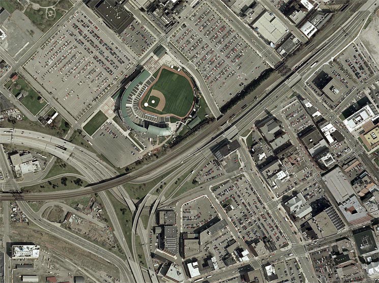 |
Here, I-490 curves off to the west and reference route 940T has its official beginning. Exit 13 from I-490 consists of a compact, almost fully directional T-junction. The CSX mainline cuts across this interchange at the same place where an entrance ramp from Platt Street joins I-490 eastbound. (This ramp is part of Interchange 12 and serves traffic from Brown and Broad Streets.) Platt Street continues eastward to Frontier Field, home of the Rochester Red Wings. The first clockwise interchange on 940T is a modified diamond interchange with North Plymouth Avenue (center) and State Street (right to top). Arranged so that there are connections to and from the west only, the interchange is complementary to Exit 14 (above).
The eastbound exit to Plymouth Avenue is part of Exit 13 on I-490; it is signed "downtown west" while the Inner Loop ramp is signed "downtown east". The first street it crosses is North Washington Street, followed by Scott Alley and Plymouth Avenue. The ramp is offset from its eastward continuation, which meets Plymouth Avenue hard by the Inner Loop overpass. At this place, it is possible to discern where the Inner Loop once curved from Plymouth Avenue onto the new freeway; the ramp itself retained this curve until it was realigned to meet Plymouth Avenue at a right angle. To the east, the ramp is met by a slip ramp from North Fitzhugh Street before crossing State Street. One block east of that, Front Street also intersected the ramp until very recently, when it was converted to a dead-end street (as shown here). All of present-day Front Street is shown in this photo, but in Rochester's boom years it was a busy market street running several blocks southward along the Genesee River.
The westbound ramp from the Inner Loop first intersects Mill Street, which leads north into the High Falls district. A pedestrian tunnel runs between the eastbound and westbound ramps at this location. The westbound ramp runs tightly at ground level between the cement embankments of the Inner Loop proper and the CSX mainline. It rejoins the ramp to I-490 westbound.
Both ramps are maintained by the state like service roads, but city
street signs refer to them as Allen Street. In fact, Allen Street was
once a continuous street of some length. Of the many streets reshaped
by construction of the Inner Loop, Allen Street remains the most
unrecognizeable without having been completely obliterated. It extends
between Brown Street and the intersection of Platt and Broad Streets
(extreme left center), forming an integral part of Interchange 12.
Another segment is reckoned to be the Exit 13 "downtown west" ramp,
although this is not on the street's original alignment. Besides these
and the
service roads already mentioned, there is one other segment just south
of the Inner Loop, crossing North Fitzhugh Street to end at State
Street.