Interchange of the Week
Monday, 8 December 2003
Monday, 8 December 2003
I-678, NY 25A & Grand Central Parkway, Queens
 |
| A
full-size image (760 kb) is
also available. Also see map. |
|
|
| A
full-size image (760 kb) is
also available. Also see map. |
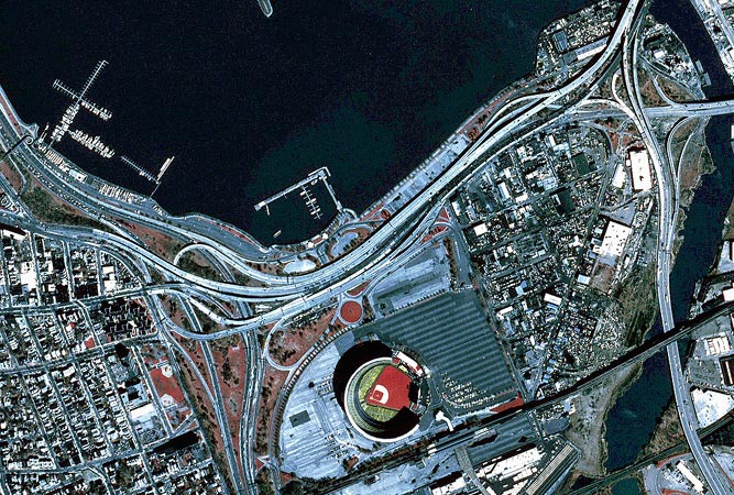
Orientation: Interstate 678 enters at bottom right on the Van Wyck Expressway and leaves at top right on the Whitestone Expressway. The Grand Central Parkway (reference route 907M) runs from top left to bottom, left of center. Northern Boulevard (NY 25A) enters at left center, running through the interchange (partly at ground level) and exiting at right on a bridge over the Flushing River. Astoria Boulevard enters between NY 25A and the Grand Central Parkway, curving south to end at NY 25A, where it becomes 114th Street.
One block south of Northern Boulevard, at left, runs 34th Avenue. Roosevelt Avenue cuts across the bottom, covered by the double-decked elevated tracks of the New York City subway's Flushing line, which carry the 7 train. At right, a pair of main streets branch from Roosevelt Avenue in a V-shape. The western of these is 126th Street, which ends at Northern Boulevard beneath the viaduct. The eastern is Willets Point Boulevard, which feeds into the eastern end of the interchange.
Shea Stadium, home of the New York Mets, is at bottom. A divided roadway serves stadium traffic along its north and west sides. From a traffic circle on the stadium road, an underpass leads to access roadways for the World's Fair Marina on Flushing Bay.
Exit numbers: From I-678, Exit 13W is for Northern Boulevard (NY 25A) westbound, and for Astoria Boulevard and the Grand Central Parkway. Exit 13E is a northbound-only exit to Northern Boulevard (NY 25A) eastbound. From the Grand Central Parkway, Exit 9E is for I-678 and for Northern Boulevard (NY 25A) eastbound. Exit 9W is a northbound-only exit for Northern Boulevard (NY 25A) westbound (from the eastbound parkway, this connection would be made at Exit 8, 111th Street, visible at upper left). Exit 9P, westbound only, is for Shea Stadium and Flushing Meadows-Corona Park.
The interchange: This interchange is difficult to decode from a map or aerial view, because of the complex weaving and branching of elevated structures (as many as seven separate roadways run parallel through the elevated section), and because Northern boulevard runs beneath these structures through the east half of the interchange. The major component of the junction is a short elevated expressway that ties together I-678 and the Grand Central Parkway, also splitting off to become Astoria Boulevard. Northern Boulevard splits, mixes and mingles, and almost all connections between these various roadways are intact. Finally, additional ramps serving Shea Stadium and the World's Fair Marina, not to mention a number of local streets, further complicate the picture. (One final visual complexity is that the eastbound side of the viaduct was being redecked at the time of this photograph.)
It is difficult to decide on a specific designation for the elevated expressway. It could be considered part of the Whitestone Expressway, as it replaced a section of that highway's predecessor parkway. It could also be seen as an extension of Astoria Boulevard: indeed, it was originally constructed as a link between the Whitestone Expressway and a never-built Astoria Expressway, and was for several years part of I-678. Finally, it can be thought of as an elevated portion of Northern Boulevard, although that street maintains continuity in its own right through the junction.
A summary of the various connections follows:
From the Grand Central Parkway eastbound: The Exit 8 ramp, at top left, is signed for 111th Street, although it actually intersects Ditmars Boulevard north of Astoria Boulevard. Exit 9E is, simply stated, a right hand ramp to Northern Boulevard eastbound and I-678, by way of the viaduct. On the way, however, it is met by a ramp from Astoria Boulevard, as well as by the westbound Exit 9E ramp. The split down to Northern Boulevard has its own right-turn channel to 126th Street.
From the Grand Central Parkway westbound: The westbound parkway has two through roadways at this point, because of horizontal clearance at the Roosevelt Avenue overpass. The Exit 9E ramp branches off from the outer roadway at bottom; there immediately follows a pair of ramps connecting to the stadium road. (This is Exit 9P. Adjacent to these is a set of cloverleaf-style ramps joing Roosevelt Avenue and the stadium road.) A re-entry to the parkway is available for stadium traffic, followed by an entrance from the stadium road for traffic to I-678 and NY 25A eastbound. The Exit 9W ramp is a left-hand exit from the inner roadway feeding directly into Northern Boulevard. North of the interchange, the outer parkway lanes are joined by the entrance ramp from the viaduct. The inner and outer lanes merge just north of this point.
From Astoria boulevard: The rightmost lane of Astoria Boulevard crosses Northern Boulevard to become 114th Street. A branch from this lane leads either to the eastbound Grand Central Parkway, or to its Exit 9E ramp. The former connection is joined by a series of turn channels from 114th Street and 34th Avenue. Most of the lanes of Astoria Boulevard follow a left-hand split at Ditmars Boulevard onto the elevated expressway. The eastbound roadway rises above the westbound lanes of Northern Boulevard where they are joined by the Exit 9W ramp (the full-size image is necessary to discern this important subtlety). Further on, this becomes the innermost eastbound roadway (the one being redecked in the photo) on the viaduct. At this point it is joined by a slip ramp from eastbound Northern Boulevard (visible as an unopened stub in the photo). The roadway is shunted to the left, and runs directly above westbound Northern Boulevard for a stretch. It is joined at 126th Street by the Exit 9E roadway. The two joined come to a split for both directions of the elevated I-678.
From I-678 northbound: Exit 13 is a single right-hand ramp that later splits: left for Exit 13E and right for Exit 13W. After the slip ramp from NY 25A westbound, there is another split. The left fork laeds to both directions of the Grand Central Parkway by way of the viaduct (the westbound parkway entrance ramp is shared by an entrance from the marina). The right fork serves the marina parking area and westbound Northern Boulevard, leading to Astoria boulevard.
From I-678 southbound: This elevated exit ramp, Exit 13W, directly feeds the viaduct, which divides into an inner roadway for Astoria boulevard, and an outer roadway for the Grand Central Parkway. In advance of this is the ramp to Northern Boulevard westbound. There is no connection from southbound I-678 to eastbound Northern Boulevard, although Linden Place connects the two east of here.
Northern Boulevard (NY 25A) eastbound: After crossing 114th Street, the eastbound roadway passes over the eastbound Exit 9E ramp and parkway mainline. It then runs alongside the Exit 9E ramp as the middle of three eastbound roadways. After the slip ramp to I-678, the roadway descends to ground level, meeting 126th Street with a channelized right turn. The road then runs at ground level along the southern margin of the interchange. A ramp splits off to meet Willets Point Boulevard, from which there is also an entrance, then circles around to meet the northbound Exit 13W ramp.
Northern Boulevard (NY 25A) westbound: The first ramp west of the Flushing River leads to I-678 southbound (northbound would be reached by Linden Place), with a slip ramp to the northbound Exit 13W ramp. West of I-678, a second ramp branches off to meet the southbound Exit 13W ramp, connecting to both directions of the Grand Central Parkway. Northern Boulevard then runs beneath the viaduct, crossing 126th Street and an entrance to and exit from the marina. As it rises back to its elevated level, Northern Boulevard appears more like part of the Astoria Boulevard connector, which it directly feeds. Northern Boulevard traffic branches off at the last moment, meeting the parkway Exit 9W ramp.