US 9 & NY 2
 |
Introduction: Last week, Interchange of the Week examined two traffic circles that have been upgraded in some way to meet more modern design standards. However, neither example could properly be called an interchange, as both the elimination of cross traffic and grade separation are inherent aspects of true interchanges. This week, we will see two more examples, both of which can be considered interchanges and represent the further degrees to which traffic circles have been upgraded around New York State.
 |
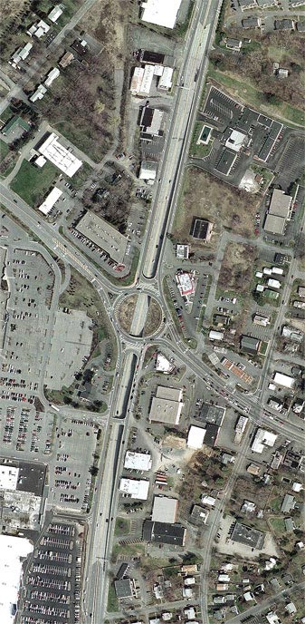
Orientation: US 9 (Loudon Road) is the north-south highway, and NY 2 (Troy-Schenectady Road) runs east-west. The large parking area at bottom left is for the Latham Circle Mall.
The interchange: In this design, through traffic on US 9 was placed on a new depressed roadway, which passes underneath the circle while leaving it fully intact. Service roads on either side of US 9 provide the connections to and from NY 2 by means of standard traffic circle movements. Another added feature is the pair of "Texas U-turn" ramps, which allow service road traffic to reverse direction without passing through the circle. Notice the overpass between the service roads, just south of the circle: this allows traffic exiting the mall to turn northbound on US 9. It does not allow northbound traffic to turn left into the mall; this is accomplished instead by using the U-turn ramp.
The north-south local road to the east of the circle is Old Loudon
Road, predecessor to US 9. Its junction here with the Troy-Schenectady
Road is
the original center of the hamlet of Latham, which since has spread
into
a large suburban district in the Town of Colonie. Latham's exponential
growth
is largely due to its position just north of Albany, just east of
Schenectady and just west of Troy, as well as on the heavily-travelled
corridor between Albany and Saratoga Springs.
 |
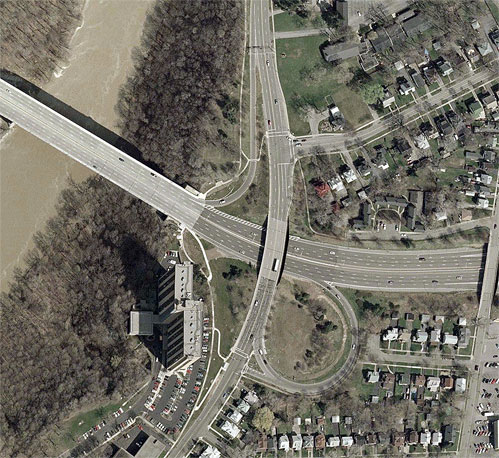
Orientation: NY 104 runs from left to right, crossing the Genesee River and its gorge by way of the Veterans Memorial Bridge (left). St. Paul Boulevard runs south to north. East Ridge Road, which at one time carried the US 104 designation (and also NY 18), comes in at top right and intersects St. Paul Boulevard just north of NY 104. NY 104 is officially the Keeler Street Expressway, although this name is not used in common speech. Keeler Street itself is nothing but the tiny dead-end street along the north side of NY 104 in this photo.
The interchange: Finally, we have a case where the original traffic circle is completely obliterated and replaced by an interchange. Not a trace of it is visible here; the only vestige that can be seen is the line of houses on East Ridge Road, which continues straight where the road itself curves to meet St. Paul Boulevard, avoiding the latter's embankment to pass over the expressway. Originally, this traffic circle formed the junction of the Veterans Bridge, St. Paul Boulevard, East Ridge Road and Keeler Street. With the building of the expressway in the late 1960's, the traffic circle was replaced by this interchange, which allows more through traffic but far fewer directional movements than did the traffic circle. In fact, at present the only connection is from the Veterans Bridge to St. Paul Boulevard, via the loop ramp at bottom right. The location of a former ramp to St. Paul Boulevard southbound is discernible, but this was removed recently and replaced by a left turn channel on the loop ramp. The ramp from southbound St. Paul Boulevard to the Veterans Bridge is not available from East Ridge Road or northbound St. Paul Boulevard, nor to trucks from any direction. This connection must be made at North Clinton Avenue, a block east of this photo, while access to and from the east on NY 104 is gained at Seneca Avenue, one block still farther east. East Ridge Road to North Clinton Avenue, and North Clinton Avenue south to NY 104, are signed as TRUCK NY 104.