Interchange of the Week
Monday, 29 January 2001
Monday, 29 January 2001
US 9, US 44 & NY 55, Poughkeepsie
 |
|
|
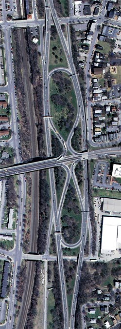
Orientation: US 9 runs top to bottom along an expressway alignment near the Poughkeepsie riverfront. US 44 and NY 55 run left to right on the eastern approach to the Mid-Hudson Bridge. Just east of this photo, the overlapped routes split into a one-way couplet through Poughkeepsie's downtown area. Alongside the US 9 expressway runs the Metro North Commuter Railroad, which terminates here (trackage continues northward on the CSX mainline). Along the far left edge runs Rinaldi Boulevard, a divided surface street.
The interchange: Although not especially complex, this interchange is of a unique design in New York State and is typical of early expressway designs. The ramps lie within the median of the US 9 expressway, which is widened to accommodate them. Note that all entrances and exits from US 9 are on the left, and that all left-turn movements involve a U-turn onto the opposing roadway. This design uses space very efficiently, which was clearly the primary concern in this narrow right-of-way between the railroad and the city center. However, all curves are very tight, resulting in necessarily slow speeds. Furthermore, serious weaving conflicts arise between entering and exiting traffic at all four points.
This interchange does not connect to local streets, but rather provides an express connection to the Mid-Hudson Bridge and downtown Poughkeepsie. Two half-diamond connections at each end of the spread median section provide access to local streets serving the waterfront and railway station. The northern pair of ramps connects to Main Street near the Metro North/Amtrak station. The southern ramps connect to Laurel Street, which provides station access by way of Rinaldi Boulevard.
 Mid-Hudson
Bridge:
Mid-Hudson
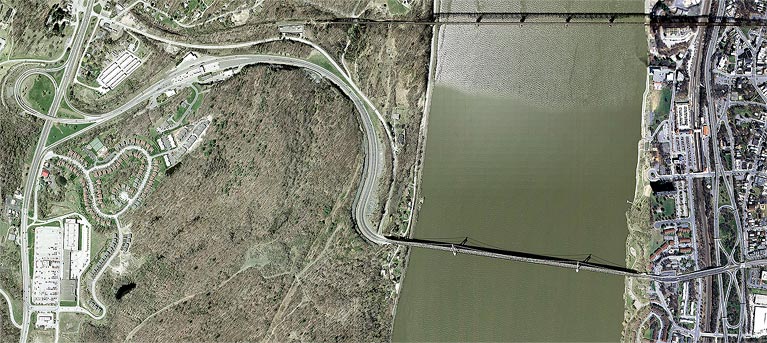
Bridge: This overview shows the complete Mid-Hudson Bridge and its
approaches. US 44 and NY 55 cross the Hudson River on an award-winning
suspension span between Poughkeepsie and Highland. The western approach
consists of a pronounced S-curve climbing the steep riverbank. At the
summit is the bridge's toll plaza (the bridge carries a $1 toll in the
eastbound direction) and its connection to US 9W (far left), a standard
"trumpet" interchange. Haviland Road, the original bridge approach
road, is visible. Also visible, at top, is an abandoned railroad
trestle that had been scheduled for demolition. However, numerous
preservation efforts from historic and recreational interests have
stayed the demolition process for the present time.