Monday, 25 December 2000
 |
| A full-size
image
(616 kb) is also available. |
 |
| A full-size
image
(616 kb) is also available. |
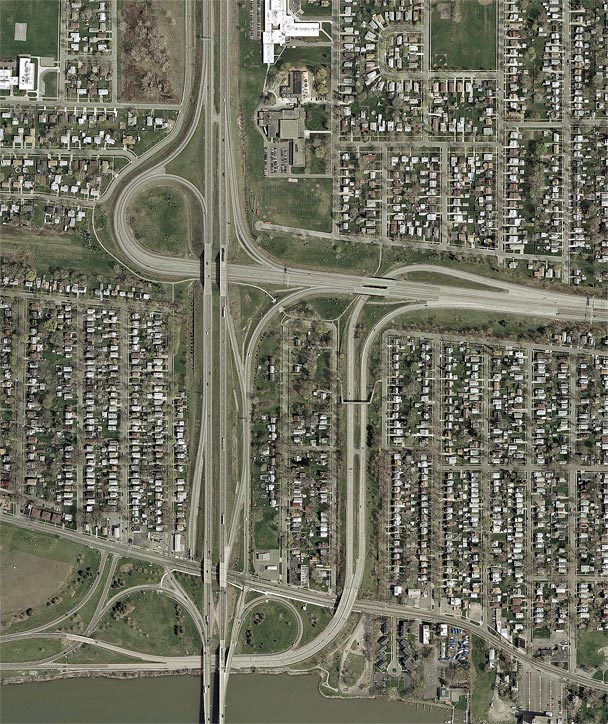
Orientation: I-190 enters at bottom on the North Grand Island Bridge over the Niagara River's east channel. It follows the Niagara Section of the New York State Thruway, which ends at the NY 384 overpass (NY 384 runs along Buffalo Avenue, the surface road near the bottom edge of the photo). From this point, I-190 continues as a NYSDOT freeway to the Lewiston-Queenston Bridge to Canada. NY 324 also enters on the North Grand Island Bridge, then terminates at NY 384, which it intersects by means of the ramps at Thruway Exit N21.
The Robert Moses State Parkway, which is reference route 957A, enters at bottom left, running between NY 384 and the Niagara River. Its official terminus is at the NY 324 overpass (the northbound offramp of Exit N21), but the road continues as a connector to the LaSalle Arterial. The LaSalle Arterial (reference route 951A) is built along an old interurban trolley grade. It enters at right and ends at I-190.
Exit numbers: From I-190, Exit N21 is the Niagara Thruway's last exit, for the Robert Moses State Parkway and NY 384. Exit 21A is for the LaSalle Arterial.
The interchange: The LaSalle Arterial meets I-190 at a standard "trumpet" interchange, a typical design used where one freeway terminates at another. This interchange is comparatively new, having been completed only within the past ten or fifteen years. This is why the exit number 21A was used here.
The interchange between I-190, NY 384 and the Robert Moses Parkway is more unusual. There are direct connections between the parkway and the North Grand Island Bridge, as well as between the parkway and the LaSalle Arterial. However, there are no connections between the parkway and I-190 to and from the north; motorists making these movements must use a short stretch of NY 384. The connections between I-190 and NY 384 amount to a full diamond interchange with the following modifications: 1) the southbound onramp is shifted slightly west of the southbound offramp, and 2) the northbound entrance ramp shares a collector/distributor roadway with the LaSalle Arterial exit ramp, so as to minimize weaving conflicts arising from the closely-spaced interchanges.
A few other points of interest are revealed in this photo. First, the northbound Exit N21 offramp begins as an elevated structure over the river, branching from the North Grand Island Bridge. Second, a pair of temporary crossover roadways is visible between the two carriageways of I-190. These were used during construction projects in which both directions were shifted onto a single roadway of I-190. Finally, several pedestrian walkways can be seen connecting the various disconnected sections of neighborhoods that were severed by the building of these roadways. The walkways share overpasses with parts of the highway, although in one instance a dedicated culvert carries one of the paths beneath an exit ramp.