Interchange of the Week
Monday, 11 December 2000
Monday, 11 December 2000
New York State Thruway - Exits 1 to 4, Yonkers
 |
|
|
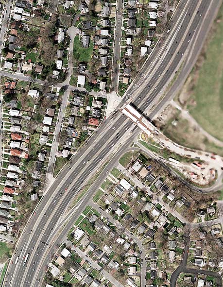
Orientation: The New York State Thruway (I-87) has an interchange with Hall Place (center) in the City of Yonkers. The flanking service roads are considered part of Central Park Avenue and are maintained by Westchester County. The service roads continue south to the next interchange (West 233rd Street and Jerome Avenue) in the Bronx. Just south of this photo, McLean Avenue passes over the Thruway, and immediately south of that (shown at right) is the starting point of the Thruway at the New York City line. I-87 continues south on the Major Deegan Expressway.
Exit numbers: Hall Place is Exit 1 on the New York State Thruway.
The interchange: This is a very typical urban
interchange design, consisting of slip ramps to and from service roads,
forming a diamond interchange with the intersecting street. However, it
is unusual in that Hall Place does not
intersect the northbound service road, crossing it instead on an
overpass, with access provided by a two-way connecting ramp. At the
time of this photo, the overpass was under construction and closed to
traffic.
In the southbound direction, Exit 1 is signed for Hall Place and
McLean Avenue, while northbound traffic for McLean Avenue is handled by
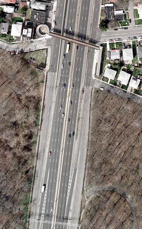
Exit 14 from the Major Deegan Expressway. (The photo at right shows
this exit ramp, as well as the southbound exit ramp for West 233rd
Street and Jerome Avenue [Exit 13]. The loop at bottom right is part of
a disused ramp allowing U-turn movements from northbound to southbound.
It passes under Interstate 87 and reconnects to the service road on the
southbound side.) Continuing northbound, the
Thruway remains in this mainline-with-service roads configuration until
Exit 5 (Central Park Avenue-NY 100). Slip
ramps serve each of the next three exits: Exit
2 (Yonkers Avenue), Exit 3
(Mile
Square Road) and Exit 4 (see below). Entrances
from all of these points are served by a single ramp north of the Cross
County Parkway. Southbound, somewhat the reverse is true: all exits are
from the ramp at Exit 4, while separate entrances are available from
Mile Square Road and Yonkers Avenue.
NOTE: Portions of the images on this page appear blurry and indistinct. This is a security measure undertaken by the NYS Office of Cyber Security & Critical Infrastructure Coordination to restrict access to imagery of certain "sensitive areas".
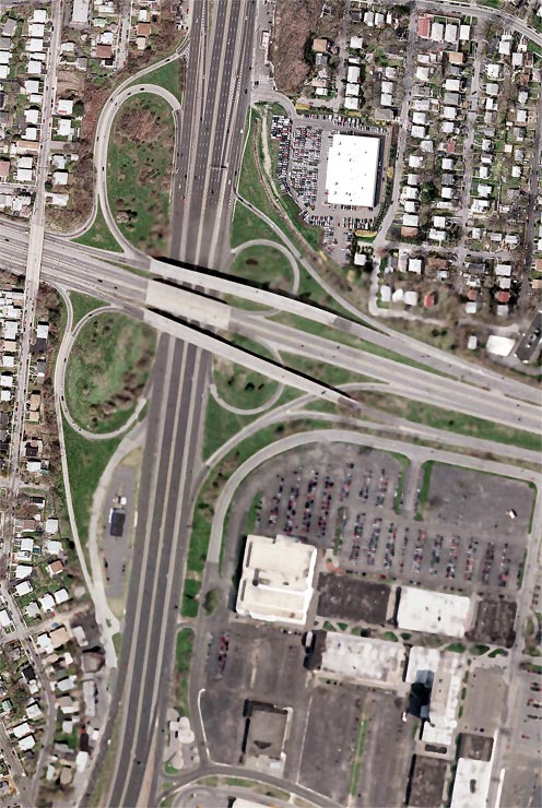 |
Orientation: The Thruway and its service roads (Central Park Avenue) run north-south, while the Cross County Parkway and its service roads run east-west.
Exit numbers: This interchange is Exit 4 for both the New York State Thruway and the Cross County Parkway.
The interchange: This is a modified full cloverleaf interchange. The Cross County Parkway's service roads are actually local traffic lanes, while the center roadway provides express service between Yonkers and Mount Vernon, bypassing the Thruway and, eastbound only, the Bronx River Parkway. The local lanes provide access to these and other local roads in Yonkers and Mount Vernon. The Thruway service roads here act as collector/distributor roadways, enabling a single ramp to provide both directions of access to and from the Cross County Parkway.
The northbound Thruway ramp for Exit 4 is at bottom. It connects to
the service road, from which access is available to the Parkway's
eastbound local or express lanes, and to the westbound express lanes
only (since the local lanes rejoin the express just west of this
interchange). The slip ramp for Exit 5 is
just north of the Cross
County Parkway overpass, while the northbound entrance ramp for Exit 4
is off the
top of this photo. As a result, a weave condition exists on the service
road between traffic entering from the Cross County Parkway and traffic
exiting to Central Park Avenue. This kind of overlapping of
interchanges is common in congested areas, especially where service
roads are involved. Also notice that northbound entry from the
eastbound Parkway is from the express lanes only. This interchange was
initially built as a standard cloverleaf junction. When the Parkway's
local lanes were added, they passed over the northbound loop ramps,
since connecting these to the new roadways would have resulted in too
tight a loop. This arrangement also eliminates the weaving problem
which would occur on the mainline between cloverleaf-style loop ramps.
The westbound-to-northbound ramp has been shifted slightly south of its
original location, to avoid traffic conflicts with commercial
properties along the northbound service road.
In the southbound direction, the connections seem simply to be the
inverse of the northbound, but some complexities arise. Indeed, the
Exit 4 offramp is north of the photo, while the Exit 5 onramp is at
top. However, there is no southbound entrance ramp for Exit 4 (although
many maps show one). Instead, traffic from the Cross County Parkway
must use the service road, passing through the intersection with Mile
Square Road, and enter the Thruway at the Exit 3 onramp. Furthermore,
there is a business within the southwest quadrant of the interchange,
with access from Central Park Avenue.